Showing posts with label Thane Creek. Show all posts
Showing posts with label Thane Creek. Show all posts
Saturday, February 14, 2015


Friday, August 15, 2014


Sunday, March 16, 2014
Ulhas River, Gaimukh Creek, Thane West

This is Ulhas River mouth. The river originates in Hills of Karjat and flows all the way and drains in Thane Creek. Above photo is of Ulhas River in Gaimukh Gaon. Massive Sand mining and land grabbing is done on its banks. All city sewage is dumped in to this river right from its source till drain. This river is famous for migratory birds but due to heavy pollution its declining. People throw their holy garbage into it without thinking that it damages the ecosystem. This is a beautiful river but its dying. Its said that there will be a water sport developed at this Gaimukh Creek stretch. Love your City, Clean your City.
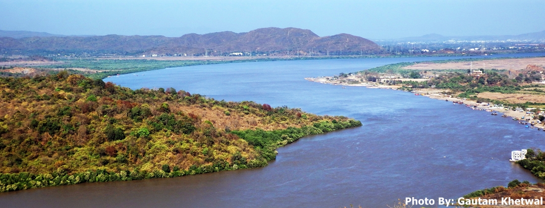
Pan photo of Thane Creek, Ulhas River
 Monsoon clouds over Gaimukh Creek Thane West


Sunday, February 9, 2014
Gaimukh Creek, Thane West

Gaimukh temple is situated aside this creek. This is Gaimukh gaon hence Gaimukh creek.


Mighty Kamadurg Peak seen behind Gaimukh Creek.

 Monsoon Clouds over Thane Creek
 Gaimukh Creek, Thane West
 Winter Morning at Gaimukh Creek
 Gaimukh Creek, Thane Vasai Creek from NH8 bridge.
 Gaimukh, Thane West
 Evening at Gaimukh Creek, Thane West

See more photos of Thane Creek
Gaimukh Chowpatty Promenade


See more photos of Thane Creek
Gaimukh Chowpatty Promenade
Tuesday, May 28, 2013
Waghbil Creek, Thane West


Monday, May 13, 2013
Chena River, Ghodbunder Road, Thane
Chena River source is from the hills of National Park. Most people call it china river but it is Chena River. In monsoon it flows fiercely and causes flood in the nearby region. Its mouth is in Thane creek. There is an old chena bridge over it and a new bridge which is Ghodbunder road. Chena village is aside of this river. There are many hotels nearby. During summer small rock dams are built to collect water. During monsoon area is full of greenery One can reach Chena river by TMT bus or Mira Road Bhayandar Bus and get down at Chena village. From there it is walkable. Slowly the river area is being destroyed due to excessive constructions, encroachments and destruction of mangroves nearby. See Bhendi Nala


Above photo is of dried Chena River bed. Since the river is not perennial, it dries up quickly after the monsoon. Water is collected by building small dams like below. But the picnickers leave all the waste behind thus polluting it.


Above photo is of dried Chena River bed. Since the river is not perennial, it dries up quickly after the monsoon. Water is collected by building small dams like below. But the picnickers leave all the waste behind thus polluting it.
Chena River during monsoon
PLEASE DO NOT THROW WASTE.
Sunday, January 8, 2012
Kolshet Creek, Thane Creek

Kolshet creek is a nice place for relaxing on the banks of Ulhas River.
 Kolshet Creek


Ganesh Visarjan is also performed here.

Kolshet Creek is one of the view points of Thane Creek. This point is used for various idol immersions, mass puja festivals, etc making it a polluting source of Thane Creek. People just come and throw loads of bag full of various materials polluting it more. Also sand mining is done beside. Kolshet Creek is a nice place for watching sunrise and moonrise. One can either come from Brahmand colony or by maintenance road, Kasheli.

There is a small ground beside the creek as shown below for playing. In monsoon this becomes a lake.

Also there is Shamshan Bhoomi here.

Also Swimming is done in Thane Creek as shown below ...


Lunar Eclipse Moon (Blood Moon) as seen from Kolshet Creek, Thane West


Subscribe to:
Posts (Atom)