The city of Thane is situated on the western banks of Thane creek with Parsik hills on the east and Yeoor hills on the west. The city was then know as Shreesthanak. It was more popularly known as the Capital of the Shilahar dynasty. The history of Thane city can be broadly categorized into 5 eras.
‘Aparant’ is the ancient name of the geographical area hosting Thane city. During the Indian expedition of the Greek Emperor Alexander, a number of philosophers, historians and geographists visited India. Among them a Greek historian ‘Tolemi’ has mentioned about the city of Thane in his writings. A famous sailor named Marcopolo had also visited Thane in 1290 ‘A.D. and noted it to be one of the best cities in the world. A place called | ‘Ghodbunder was famous for horse trading thus deriving its name from the word ghoda i.e. horse and bunder meaning port.
During this period a fabric called ‘Tansi’ was exported from Thane. During the period from 13 A.D. to 17 A.D., the Muslims, Portuguese, Marathas, & the British dynasties ruled Thane. From 810A.D. to 1260A.D. the Shilahar Dynasty ruled over Thane. The Emperors of Shilahar dynasty were disciples of Lord Shiva and the Kopineshwar Temple has been built during their reign. During this period, At this time the Shilahars also divided the city into different sections and named them as ‘padas’. it is seen that these padas exist even today by names of Naupada, Patlipada, Agripada etc.
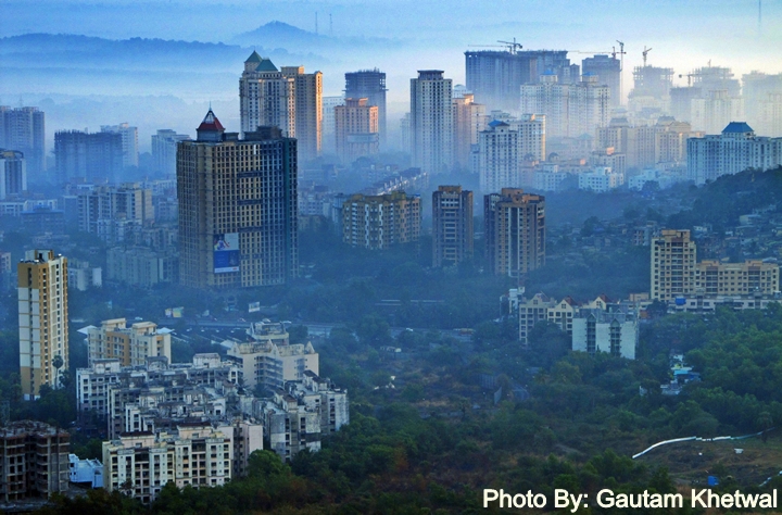
Smog during early hours over Thane City. Pollution and dust over the city has increased considerably. Suspended particulate have increased and is clearly visible. Visibility of air has reduced. Increased vehicular pollution, construction, road pavements, rock mining, etc have led to such problems. The city air as well as its creek waters are getting heavily polluted day by day. As a responsible citizen stop polluting and spreading waste.
City development alongside Ghodbunder Road. Kamandurg peak (610m) can be seen at background. Early morning photo of Thane City. Ghodbunder road can be said as the silk route of Thane. This road strip is developing at great speed and is a beautiful stretch from creeks to hills and to the city. Mangroves have been destroyed along side this road.
Many big projects have come up today in deserted Ghodbunder Road once upon a time.
1. The first photo is of Bhiwandi City 2. The second photo is of Hiranandani Estate and Patlipada with Mahuli Fort seen behind 3. The third one is of Matheran Plateau far behind 4. The fourth one is of whole Thane City with Parsik hill, Tavli peaks and Haji Malang seen behind. 5. The fifth one is the Trombay BARC Hill 6. Below is of Upvan Lake in Thane City.
Kavya Hills front and Unnathi Greens at back, Ghodbunder Road, Thane West. The mountain peak behind is the second highest peak of Sanjay Gandhi National Park with a height of 440 meters. I call it the 440 Peak.
Panoramic view of Thane City Skyline as seen from the Yeoor Hills. Whole of Thane city and mountains can be seen in the aerial view. Click the image to see it.